How big is British Columbia?
It’s big.
Vast.
Bigger than most US states, bigger than most countries.
This Canadian province is so huge that most people who live there rarely see it all. It’s so vast that you’d need well over a month to properly explore it all.
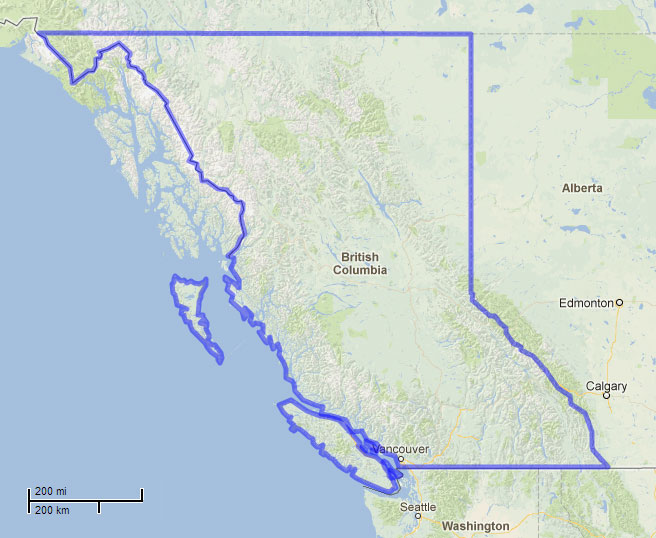
Technically BC is 944,735 km2 (364,764 sq mi), but this means nothing if you have no basis for comparison.
Even comparing BC’s area to the area of somewhere else means very little, until you visualize it… so I figured, what the heck! Let’s visualize these comparisons using MAPfrappe*.
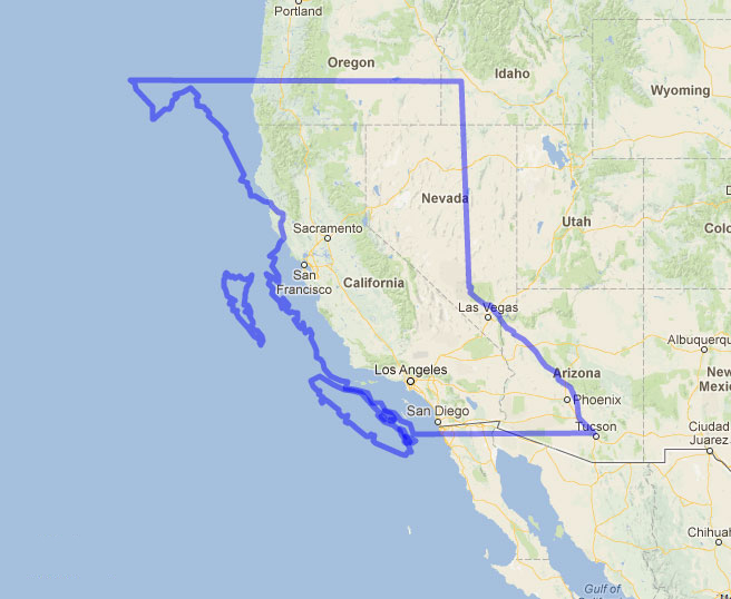
Here’s British Columbia, outlined by yours truly.
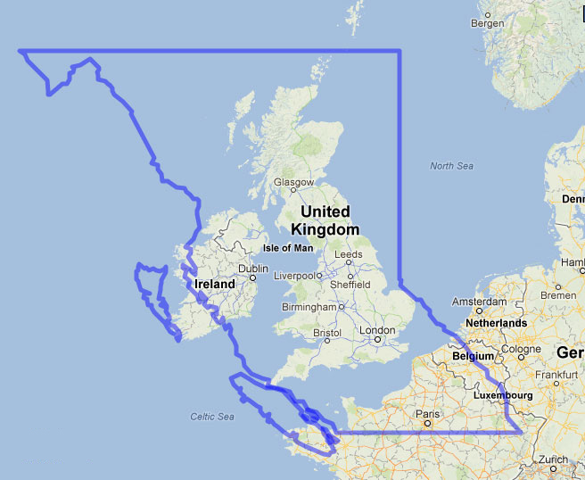
As you can see, BC is larger than the UK (243,600 km²) and Ireland (84,420 km²).
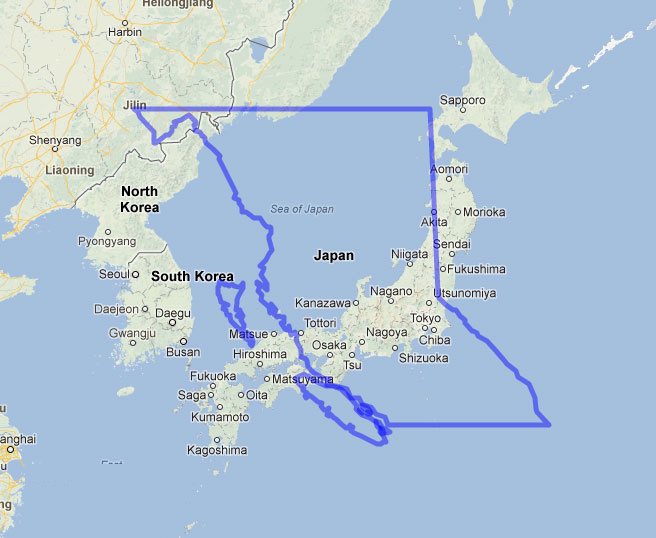
It’s bigger than Japan (377,900km2).
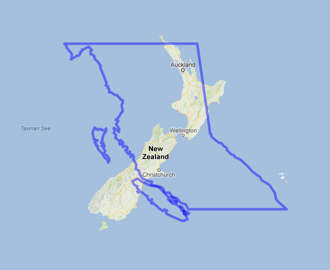
It’s bigger than New Zealand (268,700 km²).
It can eat all of California (424,000 km²).
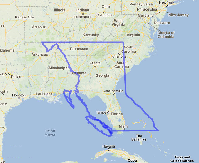
It can swallow Florida (170,300 km²) and its neighbouring states.
* MAPfrappe is a now-defunct online tool that used to allow you to draw an outline of one part of the world (ex: the outline of BC) and overlay it on another part of the world (ex: Japan), so you can properly visualize how it compares. And yes, for you cartography gurus, it does factor scale and projection distortion and makes the appropriate changes, so it’s more or less accurate for these fun (and not scientific) purposes. You can read more about the details on their website.

😀 I like this
Me too! 🙂
Thanks for sharing – This certainly displays British Columbia’s size well.
I didn’t see it on MAPfrappe so I’m basing this comment on the assumption that this feature isn’t’ there. I would like to see a feature where they can flip / rotate the outside once you create it. It would be great when you in the example of Japan and New Zealand.
I agree, that would be fantastic. MAPfrappe is pretty basic that way. It’s been years since I played around on ArcGIS, but I wonder if that’s something you could do there? Hmmm…
Interesting try, for BC is indeed large, but your method of comparison is flawed. You’re relying on polygons that were projected using a Mercator projection (like most web maps) and not with an area-preserving projection. Areal inflation in your data increases rapidly with distance from the Equator, so it becomes increasingly misleading to compare any two areas separated increasingly by latitude (e.g., BC & FL).
You’d be absolutely right if I had merely drawn this in PhotoShop, however, the method of comparison isn’t flawed because I used MAPfrappe to make this comparison.
MAPfrappe’s an online tool that allows you to draw an outline of one part of the world and compare it on another map, taking the distortion of the map projection into account and adjusting the polygon distortion accordingly.
If you take a look at the map of BC over New Zealand, for example, you’ll see that the shape of BC is extremely distorted when compared to the original outline I drew in the first map. As I dragged the outline of BC over to Florida, the outline of BC shrunk down and warped quite a bit to adjust for the map projection, yet it’s still much larger than Florida. Had MAPfrappe not taken distortion into account, BC would look even larger.
MAPfrappe explains it this way:
http://mapfrappe.com/
In the meantime, I’ll go back to my original blog post and edit to make sure this information is included going forward. As a geography major who studied cartography, these details are important to me, and I should have included them in the first place. Thanks for the reminder!
Huh. Not bad. Not bad at all.
Thanks Nick!
(in monotone nasal voice)…”flawed-FlaweD-FLAWED!! Your method of comparison did not consider the hypotenuse of the bilateral metangulargon, doubled, reversed, quadrupled, minus the sub-atmospheric cross pressure…multiplying x3 after subtracting the semi-lunar oxygen-depleted not-quite-free radical…” zzzzzzzz
A belated thanks for the support, Bruce!
good job how about texas? paul g lacny Westbank, formerly, Vancouver, terrace, Kitimat, st Lucia and Vancouver and now Westbank new cong glen rosa
Ummm. is the zoom set at the same distance for all the comparisons?
Hi Sean,
Yes, the zoom was set the same for all the comparisons.
… and actually, if you want to play around with this map, you can do so by clicking on this link: http://mapfrappe.com/?show=7467
The first map at the top is my original outline.
The second map is where you can drag the shape around onto other parts of the map and zoom in/out to your heart’s content.
If you want to create your own outline to overlay on another part of the world, you can do so by just going to http://mapfrappe.com. Warning: it’s addictive! 🙂
Size does matter, thats why I live and love BC the best place on earth, an exe Britt
Thanks for reading, Ray! BC is certainly a beautiful place in the world.
Ah! I remember now, this was what brought me to your site – a friend on SSI shared the link.
BC is HUGE and the UK is tiny – much tinier than most of the inhabitants will admit. BC is almost four times as big as the UK, but it certainly doesn’t look that on your illustration. It would appear that, if you sketch a large north/south area, the proportionality doesn’t operate within the sketch?
Thanks for reading, Christopher!
I know what you mean. I wonder if it’s just an illusion because of the unevenness of the shape of BC and the UK? If we were to, say, cut the UK into tiny pieces, it might fit into the shape of BC in such a way that it would look more like it was only a quarter the size of the province. I mean, Northern Ireland might just fit into that north-west corner of BC… almost. 🙂
I also like the analogy of crayons or beeswax… if we “melted” down the area of the UK and poured it into the shape of BC, it might just fill out one quarter of the province.
Now that would be a cool animation application.
Wouldn’t it be?! Do you know any animators looking to volunteer? 😉
When I last visited the Royal BC Museum in 2008, they had a video looping of the outline of BC, and then they’d animate the shapes of all sorts of countries – Italy, Japan, Belgium, etc. And they’d fit nicely inside the shape of BC. That’s the only other time I’ve ever seen somebody do that.
Great idea!
I’d love to see you project Saskatchewan, my home province. I would especially like to see it superimposed on Mauritania, where l’m supporting a child through World Vision.
Thamks for sharing your idea.
Your main BC map has Prince Rupert/Kaien Island as part of Alaska.
actually according to stats not only can you fit all of california into BC but also all of washington and oregon at the same time
True!
Washington (184,800 km²) + Oregon (255,000 km²) + California (424,000 km²) =
863,800km²
… which is still smaller than BC’s 944,735 km2.
Of course, it doesn’t necessarily look like that on the map above simply because of the shape of BC and the shapes of the 3 states. However, if you isolated those states and cut them up into tiny pieces, they’d certainly fit into BC with some room to spare.
Thanks for introducing me to MapFrappe. Which led me to this great old Dave Thomas skit on SCTV:
http://youtu.be/BXqKkYYALMU
How had I never seen that before? Both your comment, and your video? That’s genius! Good ol’ SCTV. Thanks Erik!
Thanks for sharing this. We have used this in our facebook group to show the differences of Vancouver Island to many places around the world. I am hoping that MapFrappe will eventually allow for rotating (compare VI to Taiwan)
Wouldn’t that be nice? A belated thank you for the kinds comments, Bill!
Interesting comparissons but area is only part of the equation. How much is habitable? How much is accessible. Northern Scotland is far more habitable and accessible than Northern BC. Much of BC is high mountain and extreme winter cold. I live half way up in Smithers. We just can grow food. Further North becomes more and more difficult.
Hmmm. I think the intention is quite clear from the outset….area is the original intention. I think you should go ahead and prepare all of the equivalent maps you have mentioned. Please email me when they are prepared. I am very happy to contribute nothing and wait for you to complete the work so that I can share it with everyone else I know and feel more important and intelligent than everyone else in the room. Awaiting the outcome of your efforts.
Yours truly,
Theguywhohasdonenothingandcommmentsoneverything
ALL of British Columbia is habitable, but only 5% is arable, meaning fertile for growing food. That is why we have the Agriculture Land Reserve, to prevent Metro Vancouver from expanding into the fertile Fraser Valley.
Love this.
Thanks.
Sean
Are you a complete nincompoop? Have you ever been to BC? Do you know how to use Google Earth? I live in BC. It is replete with massive 6 + mountain ranges, not even counting The Rocky Mountaons, and their gorges. Of the entire province actually very little is habitable…. only coastal lowlands, interior plateaus and river flood plains….as is the case with the rest of the world. Even less is arable.
Some years ago when i visited canada with my girlfriend, we arrived in Montreal by plane. We thought it would be a good idea to go to the west by tramping to visit Banff. Argh….
After two days we arrived in Toronto. We looked at a map and man, the distance is about 5000 km
from east to west. That is about the same distance that our plane did while jumping from Amsterdam to Montreal. You have no idea of canada only by looking on a map. So we returned to Montreal and went further to the east.
The canadian people always have been friendly, calm, cool and happy. Lovely people. It was a culture shock to return to germany. I very often think about that time. The real important things in life you cannot buy with money.
Pit
Now that’s called learning a geography lesson the hard way! Wow! But what a great story, Pit! Thanks for sharing! 🙂
Nice work BC Robyn. This is burning up my Facebook feed at the moment
Oh really? Cool! Thanks Geoff! It’s definitely one of my most popular posts, and I suppose for good reason. Everyone loves geospatial data visualization! 😉
I love this idea! I might have to try it for Yellowknife. Thanks!
You should!
Super neat. I love BC 😀 Thanks for this.
You’re welcome! 🙂 Thanks for reading! BC is a pretty wonderful place.
Now I need to look up population density to really blow my mind!
4.4 people/km sqrd
There are more people living in London UK then the whole population of CANADA!
You need to familiarize yourself with the basis of Cartography before posting an article like this which is very inaccurate.
Google maps, which this is using, is done with a close variation of the Mercator projection which distorts exponentially as you move towards either pole. It is used because it gives the best indication of actual direction and shows more easily than other projections relative position on a map. This is known as conformal mapping. The closest comparison in size illustrated in this article is of the UK’s and BC’s southern most borders. This article perfectly illustrates the problems with projections in perceived size and why many US students feel that their country is actually larger than Canada because they often have Robinson projection maps in their schools. For a true comparison, one must use the Peters Projection ( equal-area projection).
Hi Kelsey,
Thanks for your comments, and I’m glad you brought that up. I should clarify that I studied cartography in university, so I do know about map projections and distortions. Perhaps you missed my notes on how MAPfrappe accounts for this distortion? In any case, I agree that ideally if we wanted to do true scientifically accurate area comparisons, a Peters Projection map would be best. But since we’re comparing areas using Google Maps, which use Mercator projections, using a tool like MAPfrappe is the next best thing as it takes the distortion into account and distorts to shape of the countries accordingly. I encourage you to play around a bit on MAPfrappe to see what I mean, as you’ll notice if you trace the outline of the USA (for example), it will shrink as you move the shape closer to the equator, and it will grow bigger as you move it closer to the poles. How accurate are these distortions? That’s to be debated. However, I think they provide a better depiction of area comparisons using Google Maps than had we simply traced an outline in PhotoShop, which would be erroneous. I also feel the need to mention I created these maps for fun. I never expected this post to go viral. I wouldn’t use MAPfrappe for a serious scientific study, but for a quick and dirty area comparison, it provides the perspective I was hoping to convey.
what’s the bit north west it doesn’t cover?
That would be the Alaska panhandle.
Anna your population comment is way off. London about 8 million. Canada 35 million. Granted we still have lots of spare room though.
Damn. Good thing BC is mostly trees and repetitive landscapes in the northern parts so I wouldn’t feel the need to explore ALL of it. But Japan in comparison is a dense maze/giant metropolis that I feel would vary considerably from place to place.
Nice post Robyn:
I particularly like the comparison to CA and the South East US. When you think that the Angeleno basin has the same population as all of Canada….how fortunate are we? Lots to see but too many folk.
Very very interesting. I was just about to say, “what about projection”, then I read the final paragraph!
Love BC. Hope to be there again soon.
Ritch, from the UK (the country that’s about a quarter the size of BC!)
Yes, BUT the only city you pegged in B.C. was Vancouver and that is not even the capital. People will think it is.
Sue, what are you talking about? There’s no mention of Vancouver anywhere in this post.
Sue, she didn’t peg Vancouver… MAPfrappe did.
Pssst.. You’re confusing Japan with Zealand. Japan is a country in northern Asia with South Korea on one side and the Pacific Ocean on the other.. New Zealand is in the South Pacific in the middle of really no where..
Just FYI
I’m not confusing the two countries. Not sure where you’re getting that idea from.
[…] SOURCE: BCRobyn […]
Thanks for your post, Robyn, as it got some new love from Tourism BC! I love the comparison, and the tip to MAPfrappe is greatly appreciated, too.
A belated thank you, Henry! Apparently this blog post makes the rounds on Facebook from a variety of sources. Right now it’s being resurrected yet again. MAPfrappe is indeed a fun tool. For geography geeks out there, it’s a source of endless entertainment!
Wow being a proud Canadian and also living in bc I never actually knew how big it was until this comparison
I played around with Mapfrappe and my home country, Austria, can be almost fully submerged in Lake Superior! http://mapfrappe.com/?show=14147
Good information and I feel blessed to live in BC. Truly speaking it is not only about the size of BC but the beauty. All over BC you can find beautiful mountains and lakes
And it is full of bears. And the parts that aren’t full of bears, are full of orcas. Bam. BC Rules.
This is awesome. I spent this summer driving 20,000 kilometres just in Northern BC (draw an imaginary line from East to West that runs through Prince George – I was above it) It is good to see the vastness represented this way. Very hard to comprehend when one is on the ground.
A belated thank you for the kind comment, Simon!
Honestly who gives a rats ass if you think this is flawed. Its inevitably larger than most countries and there’s no changing that. B.C. is huge so deal with it. The projections DONT have to be perfect. The square miles and kilometers say it all. B.C. is bigger. Noe get over it. Ands its definitely not hard to believe when Canada is one of the biggest countries in the world and has so few provinces to fill the void.
[…] any idea where he was located in the province. But hey, there’s only 4.6 million people in an area the size of California, and everyone knows that Canadians are so friendly, so how hard could it be to find this […]
This reminds me of the travel agency that called me to make a reservation for a client….near his sisters place on vancouver island….but didnt have any clue where his sister lives…just pick something….just pick something? Do you have any clue how big vancouver island is? Especially to us Dutch?
Find out where she lives and call me back.
Funny story, Nancy! A decade ago I used to work at a visitor centre, and what I learned is that most first time visitors to BC completely underestimate the size of Vancouver Island, and think of it as place you can walk around in the span of an afternoon. Hopefully the travel agency worked it out for their clients!
Not only is it bigger than ANY state in the U.S. – we have the largest ranch in the world. Shhhh. Don’t tell Texas!!!!
I think you’re forgetting about Alaska.
Nope, not forgetting Alaska. I never claimed BC’s bigger than all US states, only most states.
Your scaling system is off. The distance between San Diego and L.A is not the length of Vancouver Island.
Nice try BC however down here in Australia you’d be swallowed nearly 3 times into the state of Western Australia – 2,646,000 square kilometres… But size doesn’t matter right?
Yay BC! Take a step back Alan and watch Australia get swallowed by Canada by a couple of million km2.. Size doesn’t matter, a state of mind does though (Australia is indeed a small place)..
[…] there are some significant differences in the camping/hiking in BC over the UK: -BC is huge, almost 4 times larger in area than the UK. This is pertinent, because there is only so large of a trail/campsite budget to spread over a big […]
British Columbia has an 85-member elected Legislative Assembly, elected by the plurality voting system , though in recent years there has been significant debate about switching to a single transferable vote system.
Huh. Japan, New Zealand, and even Ireland are bigger than I expected.
I know what you mean!
Great site,thx very much.live in pg,bc.its going to be n 8hr drive south to go see grandson and i’m in the middle of bc,then 2-3 hr ferry ride/wait/drive to “the island”…thats 1/2 way! Truly driving bc is something..bella coola,mica dam,kenney dam,smithers i could go on…been in pg since 1969 and as a fisherman i am in “gods” country
anyways thx for the site wife and i were curious and lo and behold here youvwere
Thanks for the comment, Pete! Sounds like you’ve had a lot of experience travelling around the best of the province. Lucky you! I only got to Bella Coola for the first time in September 2014, but what a special place. While I’ve been to Prince Rupert, I’ve yet to drive between Prince Rupert and Prince George… I’ve heard the drive is spectacular!
Super fun looking at the maps! Thanks for this blog. My brother linked me up and seeing that I live in California these days it’s nice to stay in touch with home. BC is big — I’ve seen a lot up to Dawson Creek, Prince George etc. A very beautiful province!!
Glad you enjoyed the maps, Beverley! BC is very beautiful indeed. Sounds like you’ve seen a lot of it! 🙂
Thanks for the visual, Robyn. Very enjoyable and informative, and headed for my Facebook wall. A minor point: you mention that BC is “bigger than most US states” — that should read “any US state” (unless they’ve picked up a new one recently). The closest is Alaska at about 663,000 km2. Cheers.
Whoops. Mixing km & miles — you’re right; Alaska is larger.
No worries, Gordon! Glad you enjoyed the post!
thank you this was helpful
[…] Location, location, location… Canada is a very large country, which many visitors do not understand until they arrive here. For an idea of how large our province is, please visit this link: How Big is British Columbia? […]
[…] How big is British Columbia? […]
Just loved the maps and thank you very much. I love to compare the sizes of different countries to BC using the maps. This has put things into perspective for me. Just wonderful and thank you for sharing.
Considering it’s the most mountainous province, how big would it be if you flatten it out?
Though I’ve not travelled all throughout British Columbia, I did take the train from North Vancouver to Prince George which gave me a taste of the province’s size and various types of wilderness areas.
I once rode a train from York to London in England and that was quite an experience too.
Looks like BC is kinds of a Black Hole sucking in all these other places, terrifying!
As a BC resident, I’m always happy to remind our southern neighbours (sorry, neighbors) that you can drop CA, OR and WA into BC and still have room for Maine or Rhode Island!
how about comparing BC to China, India, South America, Russia?
Size doesn’t matter it’s what portion is habitable, also take into account that only 13 percent of the Province is in private ownership the balance is Forest Land and Mountains all owned by the Crown. Since such a small portion of the Province is in private ownership the residents are faced with excessively high Real Estate prices so that home ownership is unattainable for many.
I was born in Vancouver and lived on the west coast all of my life but traveled throughout the province, and yes it is beautiful. However, what struck me was how diverse the province is. From rain forest to dry desert, alpine meadows to high prairie and that doesn’t include the islands and ocean inlets all along the province’s west coast.
I have driven across Canada, and of course, Ontario and it seemed to take forever to cross Ontario because it is wider than tall, however, I didn’t find Ontario to have the same diverse regions and climates as BC. There is a lot to choose from in BC.
[…] subsequent to grease derricks, all the way in which to the Pacific Coast. British Columbia alone is bigger than any country in Europe (as long as you don’t embody […]